|
|
|
|
Call Us !
513-232-6939 |
Topography of your project. The topography of your lot is nothing more then the roll of the land. The hills, swales, ditch lines, and pastures
all together form the contours of your property. When we do a topographic survey we are collecting this information, the elevations,
to create a map that can be used for site development.
Coming from an established benchmark or control monument we can gather elevation points and create as detailed
of a map as you may need. This is important if you are building a home or garage and need to make sure that the sanitary and
storm connections will match up with the existing utilities. Also if you are doing site grading for parking or roadways you
want to make sure that the grades will all work.
Many times we work with design professionals that need elevations or lot topography without the need to be tied into
an established benchmark or control point. What is needed in this case is to know the difference between certain elevations
on a project. This is another area where we can save you money. Benchmarks and control monuments may not be close to
your lot or project. We can set an assumed benchmark on site that everyone can work from.
We take the time to talk with you, your arcitech or your engineer to discuss exactly whats needed for your project and
how to go about getting it. We learned long ago that being effecient and keeping the costs down will bring you back to us
time and time again.
|
|
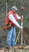
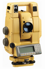
Fast ! Fast ! Fast ! We have a brand new Topcon fully robotic total station that can collect
our point elevations as fast as we can go. On large tracts of open land we can attach the survey rod onto the back of an ATV
Vehicle and take a shot every 5 seconds. With just about thirty thousands dollars invested in this piece of equipment
you can tell we take our surveying serious. You will have the information you need in record time.
Existing Topographic Maps can be viewed and purchased when hiking or considering the purchase of land for development. These maps will give you
a general idea of the topography of the land. At a later date you can have a surveyor give you a much more detailed topography
of any area that you may want to develope.
|
|
|
|
|
|
|